
- English
- Français
- Nederlands
Games Without Frontiers
by Fabrice Leroy
The Representation of Politics and the Politics of Representation in Schuiten and Peeters’s La Frontière Invisible
”ainsi fut construit jadis et se construit sans cesse le monument cartographique à jamais présent—hors-temps , hors espace—de la représentation, le monument mémorial du roi et de son géomètre.” [and thus was once built and is unceasingly built the forever present, cartographic monument—outside of time, outside of space—of representation, the memorial monument of the king and his surveyor] — Louis Marin, Le Portrait du roi (1981: 220)
”when we make a map it is not only a metonymic substitution but also an ethical statement about the world . . . [it] is a political issue.” — J. B. HarLey, “cartography, ethics, and social Theory” (1990: 6)
In a chapter of his essay Le portrait du roi [Portrait of the King], entitled “Le roi et son géomètre” [The King and His Surveyor], Louis Marin reflects on the hegemonic nature of mapping by analyzing Jacques Gomboust’s 1652 map of Paris, not only as an epistemological object characteristic of scientific endeavor during the reign of Louis XIV, but also as a political
project designed to assert and glorify Louis’s absolute monarchy (Marin 1981: 209–20). Although more recent studies on cartography have furthered the analysis of the inherent linkage between politics and the production of spatial knowledge and identity (Crampton 2002: 23), Marin’s essay remains a seminal model in the field of political semiotics and discourse analysis, and clearly shows how power relations are inscribed within representational systems, and vice versa. Interestingly, Marin’s chapter also describes quite adequately the codependency of a political leader and his official cartographer, which is at play in La frontière invisible [The Invisible Frontier], the latest, two-volume installment of Benoît Peeters’s and François Schuiten’s ambitious series of graphic novels, “Les cités obscures” [Cities of the Fantastic]. This subject mat- ter echoes a consistent network of meta-representational strategies and politi- cal themes within Schuiten and Peeters’s body of work, which I will examine in this essay.
La frontière invisible tells the story of a young cartographer, Roland De Cremer, who enters the professional world when he is appointed to the Cartography Center, a strange, dome shaped structure in the middle of a desert, in his home country of Sodrovno-Voldachia (figure 1). Although De Cremer’s new surroundings constitute the archetype of the fantastique [fantastic] locus (isolated, alienating, labyrinthine) and entail intertextual references to Dino Buzzatti or Julien Gracq narratives of a young man assigned to the remote outpost of a faceless power, the story is more Bildungsroman than fantastic melancholia, as it focuses primarily on the professional and sentimental education of the inexperienced cartographer. From the beginning, De Cremer is confronted with conflicting methodologies and agendas. Yet uncritical of his own cartographic training, he tends at first to simply objectify maps, does not question their bias or authority, and remains generally in an undialectical relationship with the documents he is required to archive, analyze, and produce. However, his understanding of mapping devices is quickly problematized, when he receives contradicting advice from two colleagues. I use the word “problematized” here in the Foucauldian sense, meaning that “an unproblematic field of experience, or a set of practices which were accepted without question, which were familiar and ‘silent,’ out of discussion, becomes a problem, raises discussion and debate, incites new reactions, and induces a crisis in the previously silent behavior, habits, practices, and institutions” (Foucault 2001: 74).
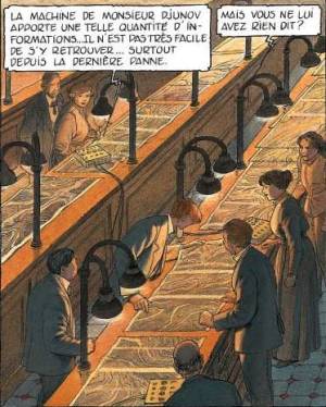
On one hand, De Cremer must adjust to a recent government mandate, which requires new scientific methods of inquiry: the collection of “objective” data by a computer-assisted process, under the supervision of the mysterious and menacing Ismail Djunov, a néotechnologue [neo-technologist] brought in to modernize the center’s methods of mapping. Djunov’s strange and tentacular machines—full of tubes, wires, buttons, and displays of all kinds (1: 31) 1)—are themselves consistent with a recurrent theme in “Les cités obscures”: the early modern machine, retro-futuristic in its appearance, part utopian technology, part monstrous device, which characterizes the alternate, otherworldly modernity of Schuiten and Peeters’s parallel universe. La frontière invisible contains other machines of this kind, for instance, some decidedly Jules-Vernian modes of transportation which include a network of suspended bicycles (1: 26–29), which provide city travelers an overhanging perspective akin to that of cartography, and giant single-wheel vehicles (2: 7–8, 39–43) that seem fantastic, yet technologically credible, like the world of the “Cités obscures” itself. Although both modes of transportation appear equally whimsical, they belong to different technological strata. The technological leap between the foot-powered bicycle and the new motorized vehicles is akin to that between the hand-drawn map and the electronically traced one, in that a new technology is making an old one obsolete.
Djunov’s machines are, in essence, mere mimetic operators: they are designed to produce a metonymic calque [traced image] of reality, to automatically translate a geographic referent into its mirror cartographic image, without any subjective interpretation (figure 2). Yet Djunov’s project, like Gomboust’s, masks a highly politicized one. His “perfect” representation, like that of Louis XIV’s official engineer, disguises a political agenda under the appearance of rigorous scientific methods and measurements (Marin 1981: 211). Operating under the authority of science, Djunov, like Gomboust, constructs a referential representation that presents itself as the exact equivalent of its real-life counterpart, as validated and self-validating universal truth. Both men of science work indeed for the raison d’état [reason of state]: Gomboust for the Sun King and Djunov for Sodrovno-Voldachia’s grim new totalitarian leader, Radisic, who demands an image of his nation -state that mirrors and justifies—Roland Barthes [1972: 109–59] would say “naturalizes,” or “mythologizes,” as it aims to present ideologically con- structed culture as nature—his imperialistic agenda, particularly the con- quest of the neighboring principality of Muhka. Djunov’s pseudoscientific conclusions are therefore preestablished and guide his research from the onset: he is to represent the state’s natural borders as they should be, or as the dominant political consensus requires them to be carved up. As Radisic himself puts it: “Ce qui compte, ce ne sont pas les cartes mais ce qu’on veut leur faire dire. J’attends de vous [les cartographes] que vous me fournissiez des arguments irréfutables dans mon combat pour la grande Sodrovnie” (1: 60). [What matters is not the maps, but what one wants them to signify. I am expecting that you (the cartographers) provide me with irrefutable arguments in my fight for the great Sodrovnia.] Of course, the concept of natural borders and its accompanying propaganda remind the reader of various twentieth-century territory disputes and their ensuing conflicts—from Third Reich expansionist justifications (Monmonier 1991: 99–107) to tensions in Palestine, Yugoslavia, or Kashmir—yet of none in particular in the transposed fictional setting, although the name Radisic undeniably evokes Serbian connotations, and a dividing wall within a city conjures up images of Berlin (Peeters 2005: 162).
As an agent of the state, mandated to visualize its body as the preconceived image of its ruling power (“L’Etat, c’est moi;” “la Sodrovno-Voldachie, c’est Radisic”), Djunov draws attention to both the power and the powerlessness of political representation. As Marin reminds us, representation is a transitive act: it supposes an equivalence or substitution between two objects, one real but absent, the other symbolic but present (9–10). Representation is also an assertive act: it authorizes and legitimates its own symbolic transformation, in this case, the transformation of actual physical force into the symbolic expression of the ability to produce force if needed (11). Force is real, but power is symbolic: the latter is therefore a fragile construct, because it hides a reluctance or inability to use force once again, to repeatedly use force, and relies on the acceptance or consensus of the public. If representation “is nothing else but the fantastic image in which power contemplates itself as absolute” (12), it is also de facto “the mourning of the absoluteness of force,” the paradoxical expression of the impossibility of absolutism. It is therefore understandable that political leaders would find attempts against their image as dangerous as those against their person. This is the conundrum in which young De Cremer will find himself in this story: an accidental and unbeknownst thorn in the side of the political representational machine and its controlling cartographic vision.
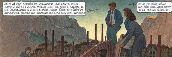
At the opposite end of Djunov, De Cremer encounters another conception of cartography under the training of his supervisor and mentor, Monsieur Paul Cicéri, an aging cartographer, whose methods lag behind the center’s new epistemological direction. A man of interpretation (always a dangerous tendency under a totalitarian regime), Cicéri is more concerned with how
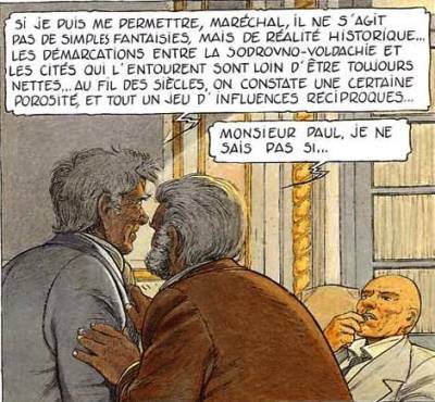
things are, with man’s Being-in-the-World, with capturing and understanding the many changing aspects of experiential reality within the framework of geographical knowledge. If, to quote Heidegger’s distinction, Djunov is a man of ontic predisposition, whose scientific approach consciously distorts, misrepresents, or simply ignores life’s real experiences or pleasures, Cicéri is, by contrast, preoccupied with ontological inquiry. For him, borders construct arbitrary lines within a continuum of human experiences (Frontière 1: 20, 60). A reader of history, he is concerned that maps, because of their synchronic bias, are fundamentally antihistorical and anti-biographical, and therefore present a false, static representation incapable of capturing an ever-changing territory and the reciprocal cultural exchanges that take place among its people (1: 60). Instead, Cicéri creates counter-maps of human beliefs, values, and cultures in order to highlight the porosity of borders and the absurdity of nationalistic rhetoric, a subversive activity that causes his downfall when Radisic takes control of the center (figure 3). The man who was once critical of Evguénia Radisic’s overblown national romanticism (1: 25) is fired by her ruthless descendant and exiled in the basement of the center, a relic living
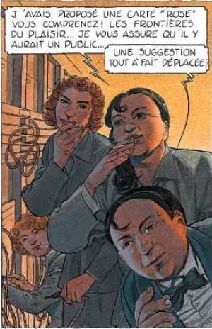
among strange Darwinian fossils of extinct species—an ironic subterranean relegation of historical perspective by a political power intent on burying any counter-knowledge provided by diachronic critical thinking under the surface of pseudo-hegemonic legitimacy. Amusingly, Cicéri will eventually be replaced by a crew of ex-prostitutes (2: 14), clearly unqualified as cartographers, but nevertheless inclined to continue Cicéri’s subversive counter-discourse, as they offer to draft a map of pleasure, unknowingly echoing Foucault’s (1985: 58–65) advocacy of the “pleasure of mapping,” a strategy to critically challenge the dominant representational paradigm by viewing mapping as a practice of freedom and pleasure, reacting against the state’s normalization of people and their individual desires (figure 4).
Caught between his sympathy for Cicéri and his devotion to his duties, as defined by Djunov’s new methods, De Cremer grows increasingly confused and weary of his function. On one hand, Radisic promotes him to the enviable position of director of the Cartography Center, and the young man appears to have a promising future in the political realm as one of the leader’s
chosen aides. The end of the story reveals that Radisic even intended to offer his niece in marriage to De Cremer, to consolidate the link between their two well-respected families (De Cremer’s great-uncle is alluded to several times in the narrative as a man of reputation and importance). On the other hand, De Cremer’s belief in the cartographic mimesis obtained through Djunov’s methods is undermined by the apparent inadequacy of their results (figure 2). Indeed, when the center’s workers attempt to recreate miniature versions of computer-imaged cities and landscapes, De Cremer appears unable to reconcile the resulting models with his own experience of their ontological referent, as if the geographic signifiers had been distorted beyond his recognition (2: 21–23; figure 5).
Such a play on the trahison des images [betrayal of images]—Peeters is an avowed Magritte admirer—is reflexive on many levels. First, the creation of models duplicates the imaging process in a self-referential, tautological loop: computer tracing reproduces reality; its reproduction is itself reproduced in the shape of models (2: 21). A model is an image of an image; it is twice removed from empirical reality—which, in this graphic novel, is itself but another image. Secondly, the entire fictional device is clearly put en abyme in the scenes (1: 48–49; 2: 20–23) where the story’s characters walk through a miniature recreation of their surroundings, as the fictional backdrop literally becomes a cardboard theater set. As a representation within the representation, such a distanciation device leads the reader to question the ontological existence of diegetic reality, as if the phenomenological “pour soi” [for itself] of the representation negated the “en soi” [in itself] of any referent. Other works by Schuiten and Peeters similarly play on models, miniatures, and other trompe-l’œil effects of scenery and simulacres [simulacra]. One remem- bers that in the first book of “Les cités obscures,” Les murailles de Samaris
[The Walls of Samaris] (Schuiten and Peeters 1988), Franz Bauer explores a city made entirely of two-dimensional panels that move around him and give him the illusion of reality, until he steps behind the machinery and realizes that the city itself is merely an image, one that is its own ontological reality. The mimetic connection between image and referent, copy and model, is often deconstructed in similar ways in other books, such as Dolorès (written by Schuiten and Peeters in collaboration with Anne Baltus, 1993), a story in which a model-maker changes dimensions and joins the miniature world of his creations. One can find similar reflexive and self-distanciating scenes in La frontière invisible, particularly in the chapter-dividing illustrations that show characters living inside a map, walking among the highly codified signifiers of cartographic representation as if they were reality itself (e.g., 2: 51; figure 6).
Thirdly, such recurrent blurring of the line between image and reality, which undoubtedly plays on what Philippe Lejeune calls our “postmodern ontological doubt,” also relies on consistent meta-narrative strategies. As various commentators have noted, the “Cités obscures” offer various reflexive images of themselves, both within the series itself (characters investigate the cities’ existence; newspapers discuss their events; archivists catalog their objects), and through corollary multimedia activities from their authors (documentaries, conferences, paintings, music). Such systematic reflexive commentary fulfills two opposite functions. One, as Benoît Peeters himself noted, can be described as a strategy of self-validation or self-reference: the invisible cities assert their own existence through an internal and external network of meta-discourse that alludes to their existence outside of the two-dimensional graphic realm. The opposite effect, of equal importance but more subtle, is to cast a permanent doubt over their existence, precisely because it is only attested to by discourse, distant echoes, and not firsthand experience of the readers—although several readers have recently begun to participate in this complex representational game by presenting themselves as dwellers of this parallel universe, as characters, or merely visitors (Peeters 2005: 151–54). If, according to Todorov’s (1976: 30–37) much debated definition, the fantastique is by essence the genre of hesitation, one could argue that it is a form of referential hesitation or ambivalence that constitutes the central fantastique device in the “Cités obscures.”
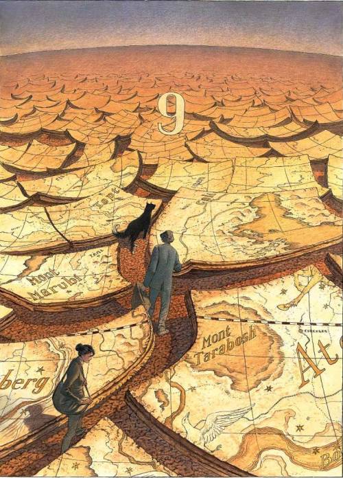
Maps, of course, are to be understood within such a system of reflexive ambivalence. The cities, which are merely image, offer a meta-image of themselves (maps), which at the same time authenticates and calls into question their existence. Interestingly, the second volume of La frontière invisible came with a double-sided ancillary map issued by the Institut Géographique National (IGN) [National Geographic Institute], a genuine French geographic society (see www.ign.fr), some of whose maps of other sites and countries (“Niger,” “Lombardie,” “Amsterdam”) are also listed on a flap of this “physical map [of] Sodrovno-Voldachia.” By inscribing the map of their fictional territory within a serialized format usually reserved for real-life locations (wittily described on the map’s own para-text as “un univers plus terre à terre” [a more down-to-earth universe] than the invisible cities, whose actual earthly presence is uncertain), Schuiten and Peeters continue to play on the same principle of referential illusion and meta-discursive validation that governed their project from the start: to convince the reader that what is discussed in overlapping sources must de facto exist (and doing so by borrowing the symbolic credit of legitimate discourses, in this case that of an official mapping institute). Furthermore, on one side of the map, they also provide an iconic representation of the respective positioning of the invisible cities, finally re- moving the reader’s blinders and allowing him or her a global, overhanging view of a world only previously accessible through separate fragments, because each book had been devoted to a restricted portion of this universe (such as Urbicande, Xhystos, Samaris, Brüsel, Pâhry). This iconic perspective fits within a network of clues about the geopolitical system of the “Cités obscures”:
Pour la page de titre [du premier album, Les murailles de Samaris], nous avons realisé la page que Franz arrache au grand livre de Samaris, et sur laquelle on peut lire: “Autour de Samaris sont huit grandes cités.” C’est alors que nous nous sommes posé pour la première fois la question de l’emplacement de ces cités. Qu’y a-t-il autour de Samaris et de Xhystos? Comment ce monde fonctionne- t-il? etc. (Peeters in Jans and Douvry 2002: 37). [For the title page [of the first book, The Walls of Samaris], we created the page that Franz tears from the great book of Samaris, on which one can read: “Around Samaris are eight large cit- ies.” This is when we asked ourselves for the first time the question of these cities’ location. What is around Samaris and Xhystos? How does this world function? etc.]
Such global positioning of the cities is, in Plato’s sense, a political endeavor in itself, as John Sallis (1999: 139) reminds us: “Discourse on the city [polis] will at some point or other be compelled, of necessity, to make reference to the earth; at some point or other it will have to tell of the place on earth where the city is—or is to be—established and to tell how the constitution (politeia) of the city both determines and is determined by this location.” Schuiten and Peeters’s “fake” map of the invisible cities relies on our geographic proficiency as readers and users of real maps. Although it turns our spatial knowledge up- side down—as it challenges the standard representations by which we make sense of the world, like Arno Peters’s famously subversive map (Crampton 2002: 17)—it forces us at the same time to process our understanding of it by filtering its signifiers through other geographic signifiers, whose shapes and attached signification we have learned to recognize in our own experience of world maps, as if we were translating one language into another by resemblance and inference. Assuming that the reader’s average geographic awareness allows him or her a mental picture of a standard world map, like the IGN’s own Carte du monde politique [Map of the Political World], he or she is necessarily led by his or her cognitive predisposition to identify recognizable elements, laid out in what appears as a jumbled order. For instance, he or she may equate the triangular shape of the Urbicande peninsula with that of India, or the contours of Mont Analogue’s island with those of Madagascar, although their scale, their orientation, and their relative positions cause him or her to permanently doubt such identifications. The peninsula that contains the city of Samaris resembles both Thailand and Florida; the Chulae Vistae Islands evoke the shape of Cuba, Japan, or New Zealand. Brüsel is situated in a territory whose shape clearly reminds us of Belgium, but it is located northwest of Pâhry (an obvious homophone of Paris), itself placed at the edge of a desert. Although it fulfills a long-standing desire for a more global perspective on this mysterious world, the map of the “Cités obscures,” because it recalls and distorts at the same time previous intertextual or inter- pictural representations, produces therefore an inherently disorienting effect, and does not in fact lift any mystery from this alternate world.
At the top of Schuiten and Peeters’s map, one finds the mention: “Une des premières cartes réellement fiables des cités obscures. Ayant été établie par les géographes de Pâhry, elle privilégie le côté ouest du continent.” [One of the first truly dependable maps of the invisible cities. Having been drawn by the geographers of Pâhry, it focuses mostly on the western side of the continent.] This caption is worth examining in several regards. “Une des premières cartes” suggests that there are other maps, which confirms the existence of this world, since it is attested to in several unconnected testimonies and documents. It also gives this particular map a special value, as a unique, rare document, like a mythical treasure map: because the other maps have disappeared or are not available for our perusal, we should treat this one as a valuable archive, a miraculous hapax that we should feel lucky to have had preserved. “Premières” may also account for the style of the map, which appears somewhat old- fashioned in comparison with the IGN Carte du monde politique, for instance. It may simply be an “early” map that uses different representational codes than our contemporary ones. Epistemologically, it belongs to a different time than ours, the alternate time of the invisible cit- ies, this retro-futuristic parallel world that resembles Jules Verne’s fictions, a nineteenth-century world that projects itself into the future.
“Réellement fiables” seems equally problematic, as it paradoxically brings into question the accurateness and the dependability of the map: if the map is indeed truly reliable, why does it have to state its reliability with such redundancy, by labeling itself as such and by resorting to an adverb of intensity? Who is making this statement? Finally, the map is identified as the result of the subjective focus of its enunciators, the geographers of Pâhry. Indeed, it places Pâhry in the relative center of the known world, as though the latter revolved around this city, just as the city revolves around the king’s palace in Gomboust’s map (interestingly, the IGN is a Parisian institute, located on the rue de Grenelle). Would the Sodrovno-Voldachian cartographers of La frontière invisible have produced the same map, or would their imaging of reality have differed as the result of an alternative political or epistemological point of view, a radically different pour-soi [for-self]? As Jeremy Crampton (2002: 15–16) reminds us, cartographic inquiry is always subject to Gunnar Olsson’s “fisherman problem”: “The fisherman’s catch furnishes more information about the meshes of his net than about the swarming reality that dwells below the surface.” In other words, the fisherman’s conjecture about the contents of the sea is necessarily related and limited to the size and shape of his fishing net. The iconic representation displayed in the Pâhrysian geographers’ map is not physical reality, but their image of it, shaped by their sociocultural conventions and agenda: to paraphrase Magritte, “ceci n’est pas un continent.” By exceeding the representational limitations of metonymic tracing, which presuppose a static and fixed object, maps are, as Deleuze and Guattari (1980: 20) have contended, open constructs:
Si la carte s’oppose au calque, c’est qu’elle est toute entière tournée vers une expérimentation en prise sur le réel. La carte ne reproduit pas un inconscient fermé sur lui-même, elle le construit. . . . Elle fait elle-même partie du rhizome. La carte est ouverte, elle est connectable dans toutes ses dimensions, démontable, renversable, susceptible de recevoir constamment des modifications. Elle peut être déchirée, renversée, s’adapter à des montages de toute nature, être mise en chantier par un individu, un groupe, une formation sociale. On peut la dessiner sur un mur, la concevoir comme une œuvre d’art, la construire comme une action politique ou une méditation. C’est peut-être un des caractères les plus importants du rhizome, d’être toujours à entrées multiples. [What distinguishes the map from the tracing is that it is entirely oriented toward an experimentation in contact with the real. The map does not reproduce an unconscious closed in upon itself; it constructs the unconscious. . . . It is itself part of the rhizome. The map is open and connectable in all of its dimensions; it is detachable, reversible, susceptible to constant modification. It can be torn, reversed, adapted to any kind of mounting, reworked by an individual, group, or social formation. It can be drawn on a wall, conceived as a work of art, constructed as a political action or as a meditation. Perhaps one of the most im- portant characteristics of the rhizome is that it always has multiple entryways.]
Trans. Brian Massumi, A Thousand Plateaus, 1987: 12
Furthermore, one could easily argue that the “fisherman’s problem” affects all representations of the obscure cities, because the various discourses or images through which the reader gains access to glimpses of this parallel universe remain similarly problematic. Frédéric Kaplan (1-23-05: 14–15) has gone so far as to liken the problem of objective reality in Schuiten and Peeters’s series to the principles of quantum physics, which famously postulate that objects exist only through the contextual act of measurement, but not outside of it.
By contrast, the other side of Schuiten and Peeters’s map, which depicts the country of Sodrovno-Voldachia, is openly political, in the mold of Jacques Gomboust’s portrayal of the Sun King’s absolute power, mirrored in the map of Paris. This is, we assume, the map that Radisic commissioned (1: 60–61), or one similar to it. In pure “Ancien Régime” [Old Regime] fashion, it is imprinted with a heraldic seal of political power—a large blazon in the up- per right-hand corner that contains a strong deictic assertion of legitimacy: two winged dragons on each side of a crown, above the inscription “Terre et Loi” [Land and Law], a formula which mirrors Marin’s (1981: 11) observation that representation not only signifies power (translates it into signs), but also “signifies force in the discourse of the law.” This map speaks of conquest and territorial claims, because it contains a “frontière contestée” [contested frontier] between Sodrovni and Mylos, another “frontière non délimitée” [undelimited frontier], a “zone neutre” [neutral zone] above Muhka, various “zones revendiquées” [claimed zones] or “zones annexées” [annexed zones], as well as fragments of a dividing wall and sections of trenches between the northwestern and the southwestern parts of the map. To the extent that it attempts to capture political flux and to stake dubious political claims, the map paradoxically represents nothing; it is an ever-changing palimpsest, a text whose imprinted signifiers are subject to being relabeled according to military conquest, and betray a doubt as to their very permanence (“zone d’incertitude” [zone of uncertainty], etc.). Besides, the map is accompanied by an amusing disclaimer at the bottom, which speaks of the fear of power within those in charge of political representation:
Le tracé des frontières n’a pas de valeur juridique. Les informations portées sur cette carte ont un caractère indicatif et n’engagent pas la responsabilité de l’IGN. Les utilisateurs sont priés de faire connaître à l’Archiviste les erreurs ou omissions qu’ils auraient pu constater. [The drawing of the frontiers has no legal value. The information included in this map is only of an indicative nature and does not bind the IGN to any responsibility. The users are asked to kindly communicate to the Archivist the mistakes or omissions that they may have noticed.]
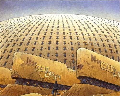
It all goes back to Marin’s (1981: 12–13) clever paradox: power, because it relies on the symbolic transformation of physical force into discourse, is also powerlessness. The language of conjecture and uncertainty, on the part of the mappers themselves, speaks of the discomfort of their positions as subjects to power, but also opens discursive gaps that undo their own absolutist construct: this is what the country is or should be, but we are not “responsible” or accountable for the potential mistakes of our representation (do not use against us the force that we are to symbolically convey), in which case power negates itself. The request to communicate mistakes to the Archivist connects this story with another meta-narrative endeavor within the series (see the volume entitled L’archiviste [The Archivist], Schuiten and Peeters 2000) and encourages, as always, the interactive cooperation of the readers. On the subject of representation as palimpsest, another telling image can be found in the first volume of La frontière invisible: a panel in which De Cremer is depicted standing in front of the Cartography Center’s giant dome (1: 10), whose external gates or loading docks have been renumbered or relabeled several times according to different codes (e.g., N 15, ZA 12, LN 103), as if to indicate that the very producer of representation is itself subject to the conceptual instability of naming or renaming. Finally, the “Cités obscures” offer us a map of their mysterious realm, but it is a map that reveals the impossibility of mapping.
If the map of Sodrovno-Voldachia is of any practical use for the reader, it is in conjunction with the travel narrative told in La frontière invisible, because it allows us to partially visualize the itinerary of De Cremer from the moment when he flees the Cartography Center. This journey is itself vague, as we often cannot match the landscapes depicted in the panels with their more abstract, larger scale cartographic equivalents. However, the map’s unexplored spaces hint at subsequent adventures in the world of the “Cités obscures”: what goes on in the “Grande Déchetterie de Rovignes” [Great Landfill of Rovignes], in the “Réserve Biologique des Deslioures” [Biological Reserve of the Deslioures], or in the “Zone de Silence du Désert de Chartreuse” [Zone of Silence of the Chartreuse Desert]? These are arguably, in Genette’s (1971: 112–14) terminology, amorces [hints] of future developments in the series.
As De Cremer becomes increasingly conscious of the arbitrary nature of the cartographic signifying process, and of the gaps between maps and their ontological referent, he meets an attractive young prostitute, Shkodrã, who brings yet another reflexive layer to his iconological confusion. Schuiten and Peeters have exploited in various other books the narrative pattern of a male héros célibataire [unmarried hero] encountering a mysterious and enticting female figure on his path to change or revelation (for example, La fièvre
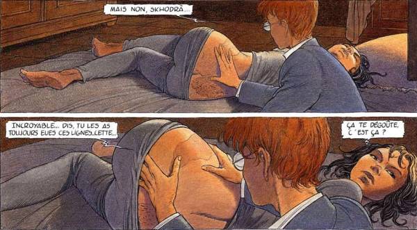
d’Urbicande Fever in Urbicand],or Brüsel). De Cremer, who reluctantly enters a brothel at Djunov’s initiative, discovers that Shkodrã refuses to appear half-naked in public as the other prostitutes do, probably to hide a strange birthmark on her backside that reminds him of one of Cicéri’s old maps, a subversive document that contradicts Radisic’s image of the State (figure 7). Although the young man is irresistibly attracted by the prostitute’s sexual availability,—his map fetish playing, undoubtedly, an important part in his attraction—De Cremer begins to fear for the safety of the young woman and improvises an escape with her.
Shkodrã (1: 34, 44–46) is an interesting figure in several regards. As a prostitute, she is an archetypal subaltern and a suitable equivalent of the territory to be mapped: she is who her client wants her to be—she is an object to name and possess. Indeed, we learn that Shkodrã is in fact the name of the village where she was born, a place that has been destroyed by border disputes and the subsequent building of a wall to divide the countries at war (2: 48). Left nameless, Shkodrã was renamed with the signifier of her birthplace, like many subalterns in history, such as slaves or immigrants. But Shkodrã, like the land to be mapped, equally escapes possession. Charles Bernheimer (1989), in his excellent essay on the representation of prostitution in the nineteenth-century French novel, clearly shows that the prostitute is a much more complex figure than she first appears to be, and that her control and possession only reveal that she ultimately escapes control. She is an agent of dispossession: indeed, the selfish male use of her sexuality and the pleasure it provides are only temporary, leaving him dispossessed and used in the face of an autonomous and subversive sexual being. Attempted control of the prostitute is a castrating, not an empowering, act. Although De Cremer’s feelings for Shkodrã clearly go beyond sexual lust, the possession of her will prove just as elusive as that of the territory.
Shkodrã is also the bearer of a map-like image, and, as such, reverses the entire paradigm of representation. Maps are normally man-made objects that attempt to present a codified image of ontological reality. They function as metaphorical substitutes (founded by mimetic resemblance with their ob- jects) and metonymic transfers (as their existence only duplicates that of the object that they trace). But they remain essentially images: “a map is not the territory it represents” (Crampton 2002: 18) but its iconic equivalent, which reminds us again of Magritte’s well-known anti-mimetic principle, “Ceci n’est pas une pipe” [This is not a pipe]. Yet Shkodrã, the ultimate reflexive device, is an ontological being, whose body mirrors a man-made epistemological con- struct, a map. Reality copies an image, life imitates art: as his methodological grasp on the world begins to fail him, De Cremer can only run away aimlessly and ponder various ontological questions. Is the image on Shkodrã’s body a mere coincidence, the simple projection of his cartographic imagination, or instead the embodiment of Radisic’s rhetoric on “natural” borders (1: 56–58, 2: 20)? Since it contradicts Radisic’s imperialistic plans and the state’s official vision, is it more or less true than the official political truth? Can reality contradict discourse? Can image be ontological? Can bodies be representations, and vice versa? And if so, can body signifiers be subversive per se: can they be deemed antipolitical in the unfortunate eventuality that their natural appearance does not match the state’s discourse?
As the army takes control of the Cartography Center, and begins to arrest its administrators, causing a wave of Kafkaesque paranoia among its employees (2: 34–38), De Cremer and Shkodrã escape by boarding a one-wheel vessel (created by Axel Wappendorf, a famous inventor of the obscure world who appears in other volumes of the series) en route to Galatograd, the state’s capital. In the meantime, fearing for their respective careers, Cicéri and Djunov denounce De Cremer’s subversive relationship with Shkodrã to Colonel Saint-Arnaud, the new military administrator of the center. Djunov accuses the young cartographer of plotting against the government by using Shkodrã’s body markings as a “weapon” against Radisic’s political agenda—“De Cremer veut l’utiliser comme une arme contre la grande Sodrovnie” (2: 41) [De Cremer wants to use her as a weapon against the great Sodrovnia]—, which is far from his true intentions. Cicéri’s motives for denunciation appear far less political: he seems to be more interested in getting the prostitute back for his own sexual use (it is implied that he had relations with her in the past).
Jumping out of the fantastic vessel as it crosses a river, De Cremer and Shkodrã continue their journey on foot across plains and forests, until they reach Shkodrã’s dilapidated hometown and the towering frontier wall that divides it in two. Despite his theoretical training, De Cremer displays a poor sense of orientation and often appears unable to situate himself in the real world: he is literally lost in a landscape whose meaning he is unable to process, a victim of his theoretical isolationism and his travel inexperience (figure 6). Reality is no longer a referent in a meta-signifying process; instead, it is its own signifier, one which bears little meaning for the confused travelers. The people whom they encounter along their aimless journey (2: 53), mostly Slavic peasants (they use the word “Da” for “yes”)—perhaps another allusion to Yugoslavia, or even to Hergé’s (1939) Le sceptre d’Ottokar [King Ottokar’s Sceptre], a classic graphic novel on a similar topic—are of little assistance, and the two fugitives advance further into unknown territories, which often bear metonymic marks of war (desert sands, abandoned ruins, spent cannon shells, and even a gigantic cemetery, 2: 54–55), while they become increasingly alienated from each other. Finally, a hunting party—composed of Djunov, Saint-Arnaud, and a few soldiers—catches up with them as they attempt to cross the valley separating Sodrovnia from the neighboring principality of Muhka, in a rowboat. The fugitives are then arrested and presented to Radisic as dangerous traitors (2: 62–68).
The dictator expresses his profound disappointment with De Cremer; he had, after all, invested his trust in him and counted on him to compose a glorifying map of his country, but the young man did not hold up his end of the bargain. In the realm of the representational process (but only within it), the cartographer had power equal to the king’s, as absolutism can only be achieved when it is signified, consumed, and accepted (as class, in Thorstein Veblen’s [1994: 68–100] analysis, depends on conspicuous displays to become reality). A simple mediator, De Cremer was apparently too naïve to realize the favor bestowed upon him, that of being considered the ruler’s equal, through a reciprocal exchange of services (Marin 1981: 54). He failed his representational duty and squandered his only opportunity to gain access to power, for the love of a subaltern, whose birthmark Radisic does not even acknowledge as a serious threat, as though De Cremer, Djunov, and Cicéri had all projected their cartographic fantasies on the prostitute’s body. Radisic has the final word on the meaning of Shkodrã’s body: it is simply meaningless and inconsequential (2: 67).
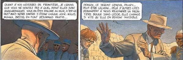
Radisic’s disdain for subversive cartographic representation, as we learn, is the product of his newfound power, acquired through the success of his expansionist politics. Mylos, Muhka, and Brüsel have already been conquered and integrated into his empire. Tomorrow, he contends, will be the turn of Genova and Pâhry. As conquest and political annexation become reality, the state has no need for the symbolic justification of propaganda. In Marin’s terms (1981: 40–46), symbolic power is not needed in times of conspicuous force, because force does not need to be represented to be effective during the actual battle phase. It is only before and after battle, first as preparatory propaganda, then as institutional preservation, that force relies on discourse. If the pen is sometimes mightier than the sword, the sword can ultimately render it useless as well: in the age of military victories, the cartographer has outlived his usefulness. Indeed, as Radisic puts it, the frontier has become invisible, because it is no longer static, but instead moves each day with the state’s military expansion (figure 8). By shifting ontologically, the frontier has become too unstable a referent to match its former signifier; reality moved faster than representation, rendering the frontier, such as initially conceived by Radisic, void as a cartographic construct. The state’s official cartographers will have to adapt to this shift, and add yet another layer to the palimpsest, by redoing the model, but on a different scale, to show all the newly acquired territory—a project to which Djunov is supposed to contribute, through his still unreliable machines (2: 67). This pronouncement and the departure of Shkodrã leave De Cremer alone, depressed, and disoriented, incapable of making sense of the world and his life, an impotent producer of signs in a fast-shifting world. Maybe one day, he concludes, he will learn again to see. Maybe one day he will again become a cartographer. However, the last few panels of the story continue to allude to De Cremer’s persistent blindness. The final images of volume 2 (71–72), which remind one of the dustcover to the same volume, show De Cremer wandering through a clearly feminized territory. The last three frames reveal, as the field of view widens from one frame to the next, a landscape in the shape of a naked female body. After the map of the territory inscribed as a birthmark on Shkodrã, we see part of the territory feminized, an ironic inversion and commentary on the previous pages, where De Cremer’s vision had been shown to be an illusion. A victim of perspective, De Cremer cannot see that he is literally walking on a woman’s body. The book therefore ends on an ultimate reversal of mimesis: the woman mirrors the landscape, the landscape mirrors the woman, representation is reality, and reality is representation, a fitting conclusion to the meta-representational maze of the Frontière invisible.
Published before in History and Politics in French-Language Comics and Graphic Novels, 2008 AD.